山地岩盤河川におけるGISを用いた遷急区間の抽出および分布特性解析
山地岩盤河川における河床遷急区間
Fluvial knickzones in mountain rivers
Fluvial erosion into bedrock is a primary process of long-term landform development. Active erosion and recession of knickzones cause bedrock river incision. However, despite the significance of knickzones in fluvial geomorphology, studies on their distribution especially in a broad area have often been limited. Previous methodologies of knickzone identification have also been qualitative.
地形解析
Landform analysis using DEMs and GIS
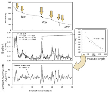
GIS and DEMs enable quantitative and broad-scale analysis. Spatial correlation between knickzones and other landform features such as landslides can be also examined. This study provides a method of quantitative identification of knickzones and an examination of their distribution.
遷急区間の存在条件
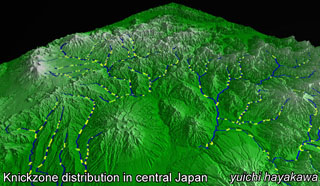
Distribution of knickzones
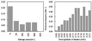
河床勾配が急な上流域に多く,地質の影響は概して弱い. Knickzones are abundant and distinct in steep upstream reaches, while influences of rock types on knickzone distribution are weak. Distinct knickzones are well observed at upstream reaches.
遷急区間の成因
How knickzones are formed?
大規模な水理的条件による形成. Possible origin of knickzones is hydraulic actions which cause riverbed features like step-pool morphology but in a much large scale.
火山活動や地殻変動による形成. Tall and steep knickzones in middle to lower reaches suggest origins by tectonic and volcanic activities.
関連文献
- Hayakawa, Y.S. / Oguchi, T. (2006): DEM-based identification of fluvial knickzones and its application to Japanese mountain rivers. Geomorphology, in press.
Copyright © 2006 Oguchi-Lab. All rights reserved.
created on 2006/5/31