DEMを用いた流域の縦・横断面形の解析
流域の縦・横断面形
Longitudinal and transverse profiles of a watershed
Longitudinal and transverse profiles of a watershed are useful to describe watershed structure in more detail than simple morphometric attributes such as basin length, relief, area, perimeter length, and the elongation and circularity ratios. However, such studies on watershed profiles have been relatively rare.
In this study, DEMs with a 1-m resolution for small bare lands and those with a 10-m resolution for broad forested areas in Japanese hills and mountains were utilized for quantitative analyses of longitudinal and transverse profiles of watersheds, with special attention to change in watershed form with regional relief.
縦・横断面形の抽出
Extraction of longitudinal and transverse profiles
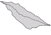
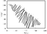
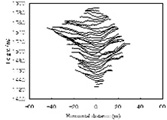
To examine details of longitudinal and transverse profiles in relation to local topographic variations, subwatersheds within each study area were delineated. The longitudinal profile was extracted from the summit to the mouth of a subwatershed. A series of transverse profiles of a subwatershed was extracted along the master stream utilizing a spline smoothing method (Fig.1).Statistical morphometric parameters representing the shape of these profiles were investigated. Methods to classify the profiles and to evaluate their anomaly from smooth shapes were also developed.
| (A) | (B) | (C) |
 |
 |
 |
縦・横断面形および流域全体の地形的特徴と起伏の関連
Relationships among longitudinal, transverse and overall subwatershed characteristics
Although some of the obtained parameters indicate that the longitudinal and transverse characteristics of watersheds are systematically related, they also play different roles in determining the entire watershed topography. For instance, average watershed slope in the high-relief areas mainly reflects the longitudinal slope, while the effects of the transverse slope become stronger in the lower-relief areas. Most topographic characteristics of watersheds in the high-relief areas are simpler and more organized than those in low- to middle-relief areas, indicating that high-relief terrains get closer to equilibrium conditions. However, geomorphological complexity of watersheds does not always decrease with increasing relief, because differences in bedrock strength also affect watershed topography.
参考文献
- Lin, Z. and Oguchi, T. (2006): DEM analysis on longitudinal and transverse profiles of steep mountainous watersheds. Geomorphology (in press).
Copyright © 2006 Oguchi-Lab. All rights reserved.
created on 2006/5/31